![](/images/other/stat-length.png)
![Randonnée Marche Torroella de Montgrí - estartit cala Pedrosa - Photo](https://media.geolcdn.com/t/1900/400/ext.pjpeg?maxdim=2&url=https%3A%2F%2Fstatic1.geolcdn.com%2Fsiteimages%2Fupload%2Ffiles%2F1553511878bg_sport_marche.png)
estartit cala Pedrosa
jopa
Utilisateur
![Longueur](/images/other/stat-length.png)
Longueur
9,3 km
![Altitude max](https://static1.geolcdn.com/siteimages/upload/files/1508320355ic_sort_altitude_max_24dp.png)
Altitude max
170 m
![Dénivelé positif](https://static1.geolcdn.com/siteimages/upload/files/1508320355ic_sort_den_pos_24dp.png)
Dénivelé positif
308 m
![Km-Effort](/images/other/stat-length.png)
Km-Effort
13,4 km
![Altitude min](https://static1.geolcdn.com/siteimages/upload/files/1508320355ic_sort_altitude_min_24dp.png)
Altitude min
3 m
![Dénivelé négatif](https://static1.geolcdn.com/siteimages/upload/files/1508320355ic_sort_den_neg_24dp.png)
Dénivelé négatif
306 m
![Boucle](https://static1.geolcdn.com/siteimages/upload/files/16400158638029165_repeat_loop_refresh_sync_direction_icon.png)
Boucle
Non
Date de création :
2018-04-18 00:49:51.261
Dernière modification :
2018-04-18 00:49:51.261
![Marche](https://static1.geolcdn.com/sitytour/trail-icons/101.png)
5h03
Difficulté : Facile
![Scannez ce code QR pour ouvrir la randonnée dans l'application SityTrail](https://capi.geolives.com/qq0zvz2zws4bq2lad0pu/sitytour/trails/945391/qr.png?size=200)
Application GPS de randonnée GRATUITE
À propos
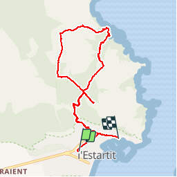
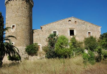
Randonnée Marche de 9,3 km à découvrir à Catalogne, Gérone, Torroella de Montgrí. Cette randonnée est proposée par jopa.
Description
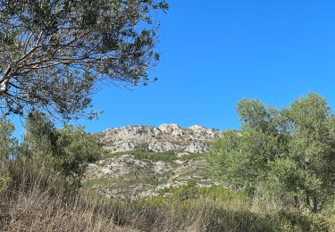
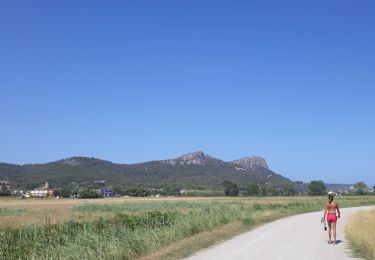
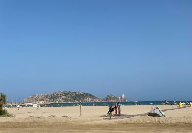
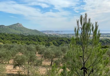
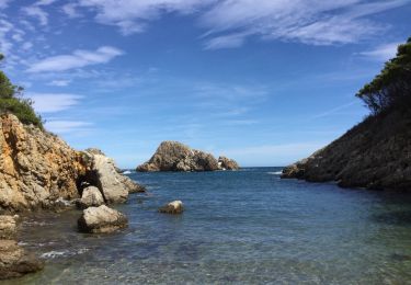
Montée dans les pins, descente jusqu'à très jolie plage Pedrosa, remontée sur le plateau avec vue sur Rosas et sa baie , le massif du Canigou .... redescente sur l'Estartit par le chemin de l'aller.
Localisation
Pays :
Espagne
Région :
Catalogne
Département/Province :
Gérone
Commune :
Torroella de Montgrí
Localité :
Unknown
Départ:(Dec)
Départ:(UTM)
516113 ; 4655604 (31T) N.
Commentaires
Randonnées à proximité
![Randonnée Marche Torroella de Montgrí - Antic quartel de les bateries de costa franquistes - Photo](https://media.geolcdn.com/t/375/260/f6cec865-06f5-4a83-99c2-38b401c4390f.jpg&format=jpg&maxdim=2)
![Marche Marche](https://static1.geolcdn.com/sitytour/trail-icons/101.png)
Antic quartel de les bateries de costa franquistes
Marche
Moyen
Torroella de Montgrí,
Catalogne,
Gérone,
Espagne
![](/images/other/stat-length.png)
3,4 km | 4,3 km-effort
1h 5min
![](https://static1.geolcdn.com/siteimages/upload/files/16400158638029165_repeat_loop_refresh_sync_direction_icon.png)
Oui
![Randonnée A pied Torroella de Montgrí - SL-C 20 Cala Pedrosa i Cala Feriol - Photo](https://media.geolcdn.com/t/375/260/43b4c9b4-e81c-4558-9e0a-fafd0f01e354.jpeg&format=jpg&maxdim=2)
![A pied A pied](https://static1.geolcdn.com/sitytour/trail-icons/100.png)
SL-C 20 Cala Pedrosa i Cala Feriol
A pied
Facile
Torroella de Montgrí,
Catalogne,
Gérone,
Espagne
![](/images/other/stat-length.png)
9 km | 14,4 km-effort
3h 17min
![](https://static1.geolcdn.com/siteimages/upload/files/16400158638029165_repeat_loop_refresh_sync_direction_icon.png)
Oui
![Randonnée Marche Torroella de Montgrí - Castel de mont gris variante - Photo](https://media.geolcdn.com/t/375/260/384149e3-08c2-4791-ab39-4aa2f75bd66d.jpg&format=jpg&maxdim=2)
![Marche Marche](https://static1.geolcdn.com/sitytour/trail-icons/101.png)
Castel de mont gris variante
Marche
Difficile
Torroella de Montgrí,
Catalogne,
Gérone,
Espagne
![](/images/other/stat-length.png)
8,8 km | 13,3 km-effort
4h 28min
![](https://static1.geolcdn.com/siteimages/upload/files/16400158638029165_repeat_loop_refresh_sync_direction_icon.png)
Oui
![Randonnée Marche Torroella de Montgrí - gr92-12 - Photo](https://media.geolcdn.com/t/375/260/5055cf24-b82c-4ff3-a89a-af51b833abda.jpg&format=jpg&maxdim=2)
![Marche Marche](https://static1.geolcdn.com/sitytour/trail-icons/101.png)
gr92-12
Marche
Moyen
Torroella de Montgrí,
Catalogne,
Gérone,
Espagne
![](/images/other/stat-length.png)
19,8 km | 26 km-effort
8h 27min
![](https://static1.geolcdn.com/siteimages/upload/files/16400158638029165_repeat_loop_refresh_sync_direction_icon.png)
Oui
![Randonnée Marche Torroella de Montgrí - gr9213 - Photo](https://media.geolcdn.com/t/375/260/62fd0af2-5af0-4df1-a94d-fcaa6e221ce3.jpg&format=jpg&maxdim=2)
![Marche Marche](https://static1.geolcdn.com/sitytour/trail-icons/101.png)
gr9213
Marche
Très difficile
Torroella de Montgrí,
Catalogne,
Gérone,
Espagne
![](/images/other/stat-length.png)
19,8 km | 26 km-effort
98h 15min
![](https://static1.geolcdn.com/siteimages/upload/files/16400158638029165_repeat_loop_refresh_sync_direction_icon.png)
Oui
![Randonnée Marche Torroella de Montgrí - Estartit a - Photo](https://media.geolcdn.com/t/375/260/3b7f9bc5-5119-43f7-8b75-2ec9d20df26b.jpg&format=jpg&maxdim=2)
![Marche Marche](https://static1.geolcdn.com/sitytour/trail-icons/101.png)
Estartit a
Marche
Moyen
Torroella de Montgrí,
Catalogne,
Gérone,
Espagne
![](/images/other/stat-length.png)
7,6 km | 11,2 km-effort
2h 39min
![](https://static1.geolcdn.com/siteimages/upload/files/16400158638029165_repeat_loop_refresh_sync_direction_icon.png)
Oui
![Randonnée A pied Torroella de Montgrí - Ruta del Vent - Photo](https://media.geolcdn.com/t/375/260/15b6e9e1-2e07-4c25-b5da-49b77848bc8f.jpeg&format=jpg&maxdim=2)
![A pied A pied](https://static1.geolcdn.com/sitytour/trail-icons/100.png)
Ruta del Vent
A pied
Facile
Torroella de Montgrí,
Catalogne,
Gérone,
Espagne
![](/images/other/stat-length.png)
5,8 km | 6,9 km-effort
1h 33min
![](https://static1.geolcdn.com/siteimages/upload/files/16400158638029165_repeat_loop_refresh_sync_direction_icon.png)
Oui
![Randonnée Marche Torroella de Montgrí - Montgris : Ermitage - Photo](https://media.geolcdn.com/t/375/260/29ccc31c-49cc-4590-9299-4aad59a89dbb.jpg&format=jpg&maxdim=2)
![Marche Marche](https://static1.geolcdn.com/sitytour/trail-icons/101.png)
Montgris : Ermitage
Marche
Moyen
Torroella de Montgrí,
Catalogne,
Gérone,
Espagne
![](/images/other/stat-length.png)
7,8 km | 11,3 km-effort
4h 1min
![](https://static1.geolcdn.com/siteimages/upload/files/16400158638029165_repeat_loop_refresh_sync_direction_icon.png)
Oui
![Randonnée Marche Torroella de Montgrí - Estartit - Photo](https://media.geolcdn.com/t/375/260/26658687-5b87-48e2-b83d-78324e2aa1a5.jpg&format=jpg&maxdim=2)
![Marche Marche](https://static1.geolcdn.com/sitytour/trail-icons/101.png)
Estartit
Marche
Moyen
Torroella de Montgrí,
Catalogne,
Gérone,
Espagne
![](/images/other/stat-length.png)
11,5 km | 17,4 km-effort
5h 42min
![](https://static1.geolcdn.com/siteimages/upload/files/16400158638029165_repeat_loop_refresh_sync_direction_icon.png)
Oui